*Predictions may vary from expert to expert and are subject to change.*
In what’s looking like a re-run from last year, a trio of weather experts are predicting the coming months to be hot and dry for most of the country.
“Overall, just like last summer, I think we’re looking at one of the hotter summers on record,” said Carol Connare, editor at The Old Farmer’s Almanac.

Click map to enlarge
IT’S GOING TO BE A HOT ONE: The Old Farmer’s Almanac is predicting most of the country will experience above-normal temperatures this summer. (Courtesy of The Old Farmer’s Almanac)
Paul Pastelok, expert senior meteorologist/lead long range forecaster for AccuWeather, said he’s not seeing a whole lot of below-normal temperature areas across the country for the three-month average and predicted there will be bouts of severe weather on the docket.
“I think there are going to be some heat waves that percolate from time to time in the Southwest Plains and the Northern tier of the nation, especially the Upper Midwest and Great Lakes,” Pastelok said.

Click map to enlarge
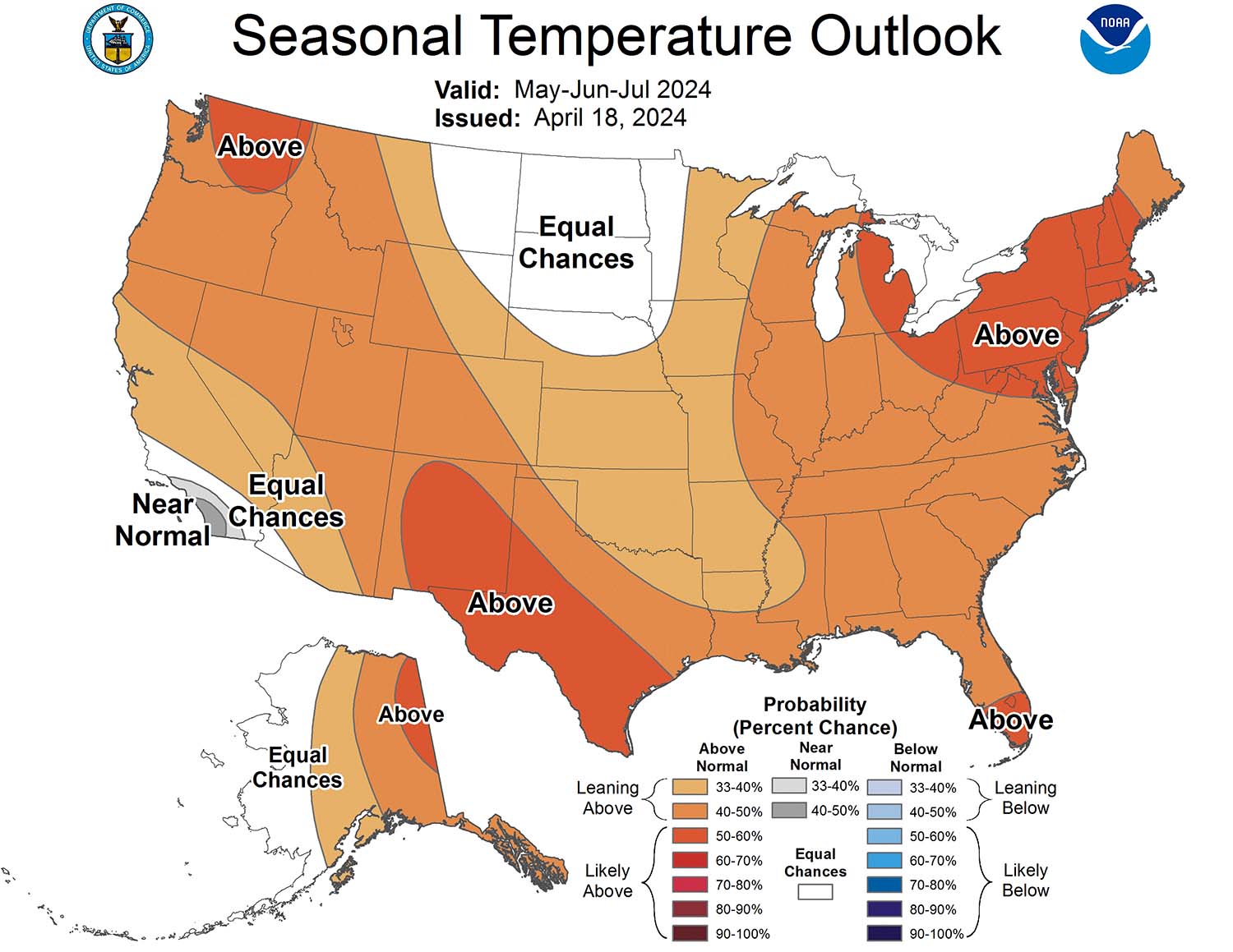
LITTLE REPRIEVE: Above-average summer heat is likely to engulf most of the country. (Courtesy of NOAA)
Anthony Artusa, CPC Meteorologist for NOAA, also said for the temperature outlook in May, June, and July, most of the lower 48 will be above normal.
In some areas, drought is likely as precipitation is expected to dip below normal, but there could also be periods of high-intensity weather, including tornadoes and Derechos, impacting the middle of the country with tropical storms and hurricanes possibly arriving in the southern portion of the country around August.

Click map to enlarge
PRECIPITATION: While portions of the east coast may see some good precipitation, the rest of the county is expected to be average, or below average.(Courtesy of NOAA)
Regardless of where an HVAC contractor is located, energy consumption and cooling demand will be elevated, while higher humidity levels are more likely to cause comfort issues.
Northeast
Artusa: Trends over the past few decades support higher odds of relatively warm temps.
Connare: Temps look to be above normal, rainfall below normal. The hottest periods will be early June and mid-July. Overall, temps about 4° above average with precipitation below normal for June and July.
Pastelok: With last summer being wet, especially in July, this year will be drier and hotter in comparison. June is looking to be 2-3° above average and, in places like Upstate New York, it could be 4-5° above in June.
“I think we’re going to be using a little bit more energy across the Northeast, compared to last year,” Pastelok said.

Click map to enlarge
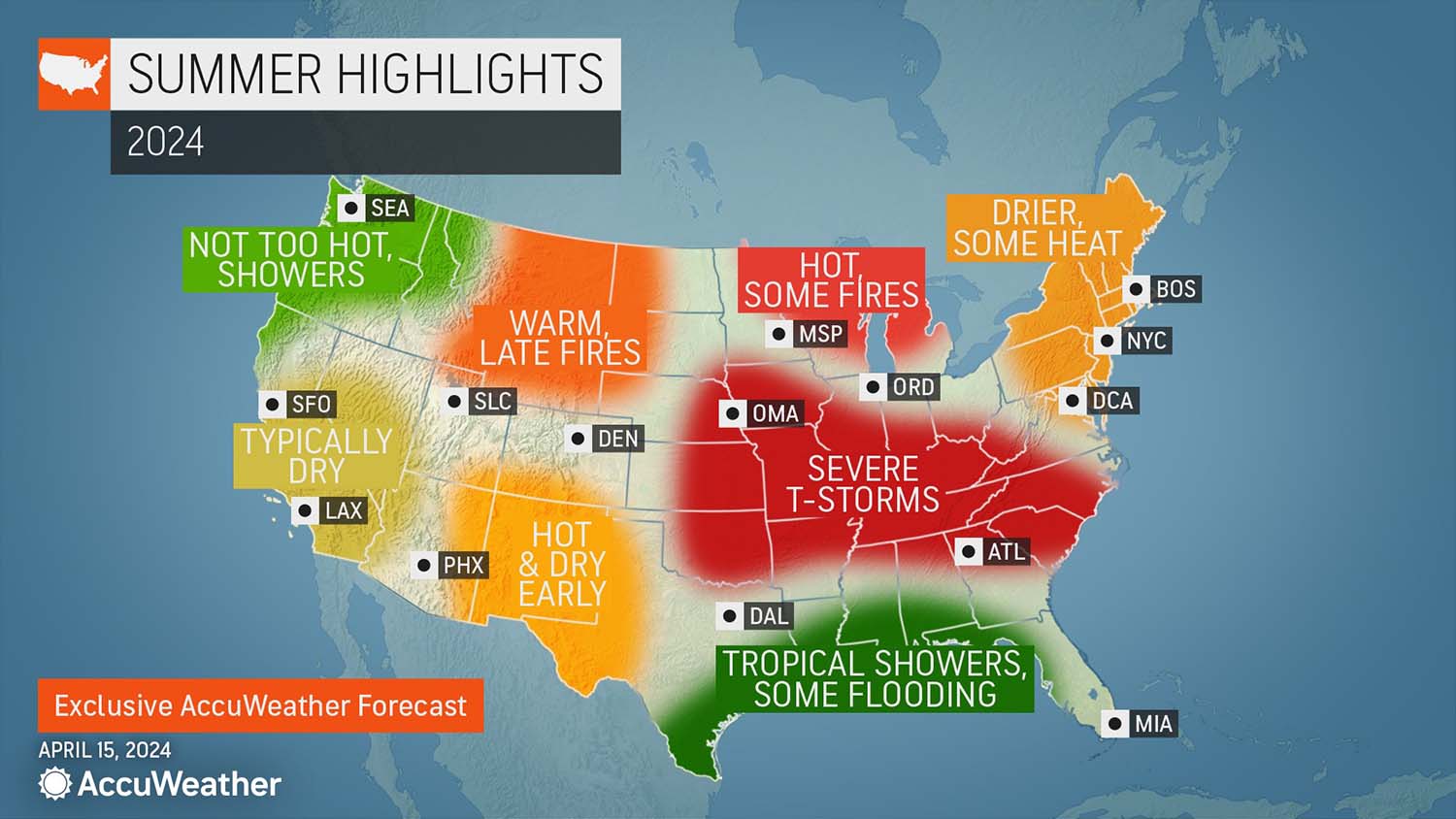
SUMMER HIGHLIGHTS: Be on the lookout for fires, severe thunderstorms, and some flooding in the coming months. (Courtesy of AccuWeather)
Atlantic Corridor
Connare: Hotter than average with rainfall below normal in the north and above normal in the south. Hottest periods are early July, late July, and early and late August. Also looking at a tropical storm in late August.
Pastelok: June will be a busy month for severe weather, depending on moisture levels and how warm it gets. When compared to the average, it won’t be as impressive compared to parts of the Northeast, but still mild, warm, and hotter compared to 2023.
There will also likely be more 90°-plus days in places like Washington D.C. Last year, there were around 32 of these days, and the average in 40, but Pastelok thinks it will be well into the 40s this year.

Click map to enlarge
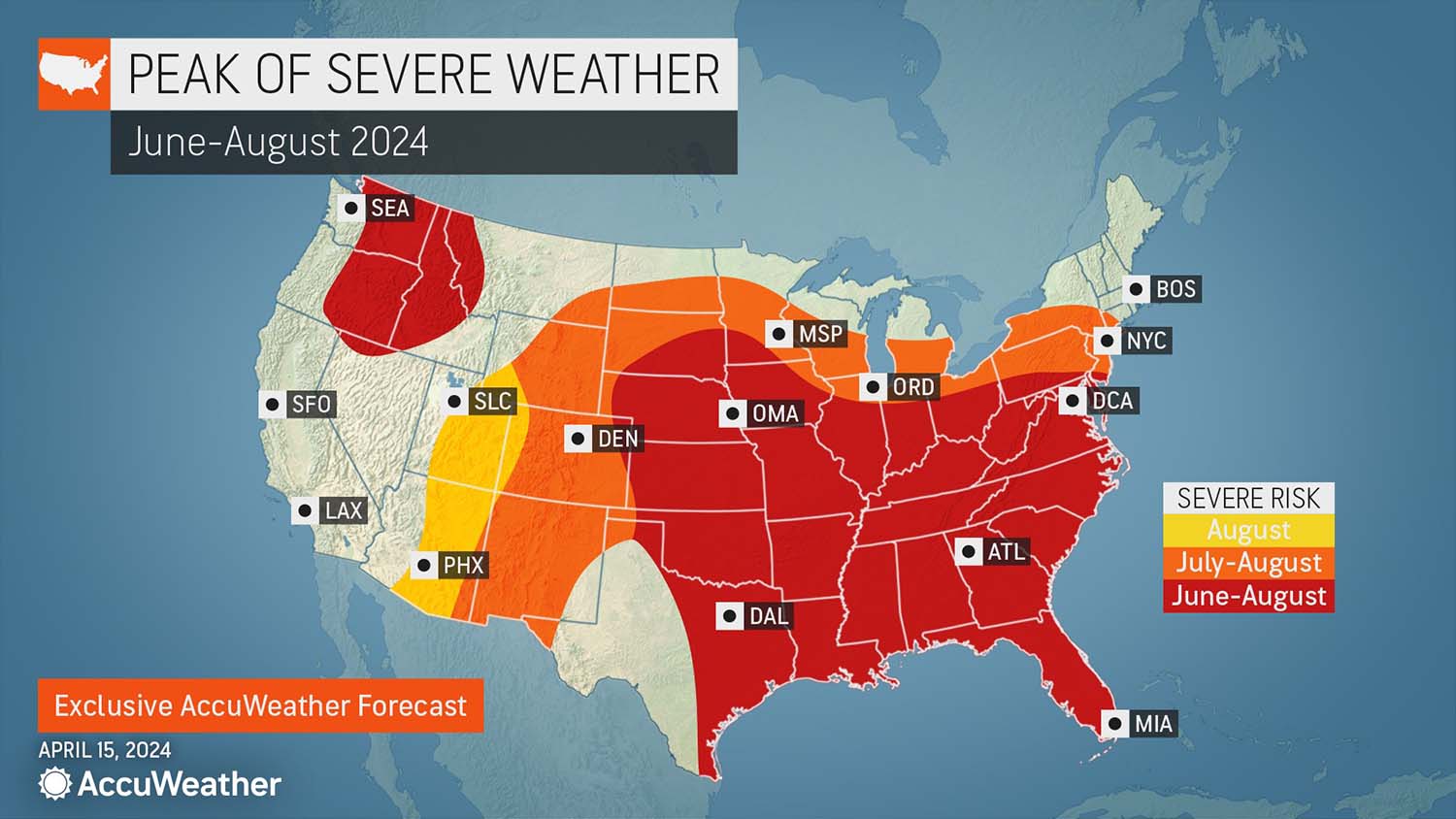
PEAK SEASON: A chart courtesy of AccuWeather depicts when severe weather is likely to hit across the country. (Courtesy of AccuWeather)
Appalachians
Connare: Temps below normal, same with precipitation. Hot periods will arrive in early July and early and late August.
Pastelok: In the northern areas, drier and hotter, 2-4° above average, with the southern areas closer to average to slightly above in some spots. June could run higher on precipitation, which will keep it from getting too hot compared to the norm.
But Pastelok is also predicting humidity issues, which will keep the “real feel” temperature up, resulting in a likely increased demand for HVAC cooling.
“Other than that, I don’t think that it’s too extreme on temperatures in the Appalachians, especially the Southern Appalachians,” Pastelok said.
Southeast
Artusa: Across much of the Southeastern quarter, extending up into southern New England, the odds are tilted toward above-normal precipitation.
Connare: Cooler than normal by a few degrees, nothing wildly off, with hottest periods June, early July, and late July into mid-August. Above-normal rainfall toward the east and below-normal to the west.
“We’re also saying to watch for a hurricane in August in the southeast,” Connare said.
Pastelok: Typical heat and humidity, with nothing too extreme as far temps go, which will be slightly above average. He is seeing a lot of tropical moisture in June and August.

Click map to enlarge
A LITTLE HERE, LESS THERE: Excluding a portion of the country’s interior, AccuWeather is predicting lower precipitation this summer. (Courtesy of AccuWeather)
Florida
Connare: Above normal temps and below normal rainfall. Hottest periods in late June and early July. Hurricanes are also a possibility in late August. June will have 4 inches less precipitation than normal, with 2 inches less for July and August.
“So a pretty dry summer,” Connare said.
Pastelok: June and July will be fairly typical, trending slightly above, with August below because of the amount of moisture that will hold temps down.
Pastelok said AccuWeather is forecasting a big tropical season.
“They could be in line for some activity, especially getting into August,” Pastelok said.
Lower Lakes
Connare: Temps warmer to the east and cooler to the west, with hottest periods in early and mid-July. Rainfall above normal across the region, with the heaviest in July at 4 inches above normal.
Pastelok: A drought will expand in this area, which will have an impact on temps going into summer. The drought will be worse farther north, but the lower lakes will be impacted at times as well. The region will be right on the edge of some severe weather in June and July, but most will go to the south. Temps are expected to trend above normal.

Click map to enlarge
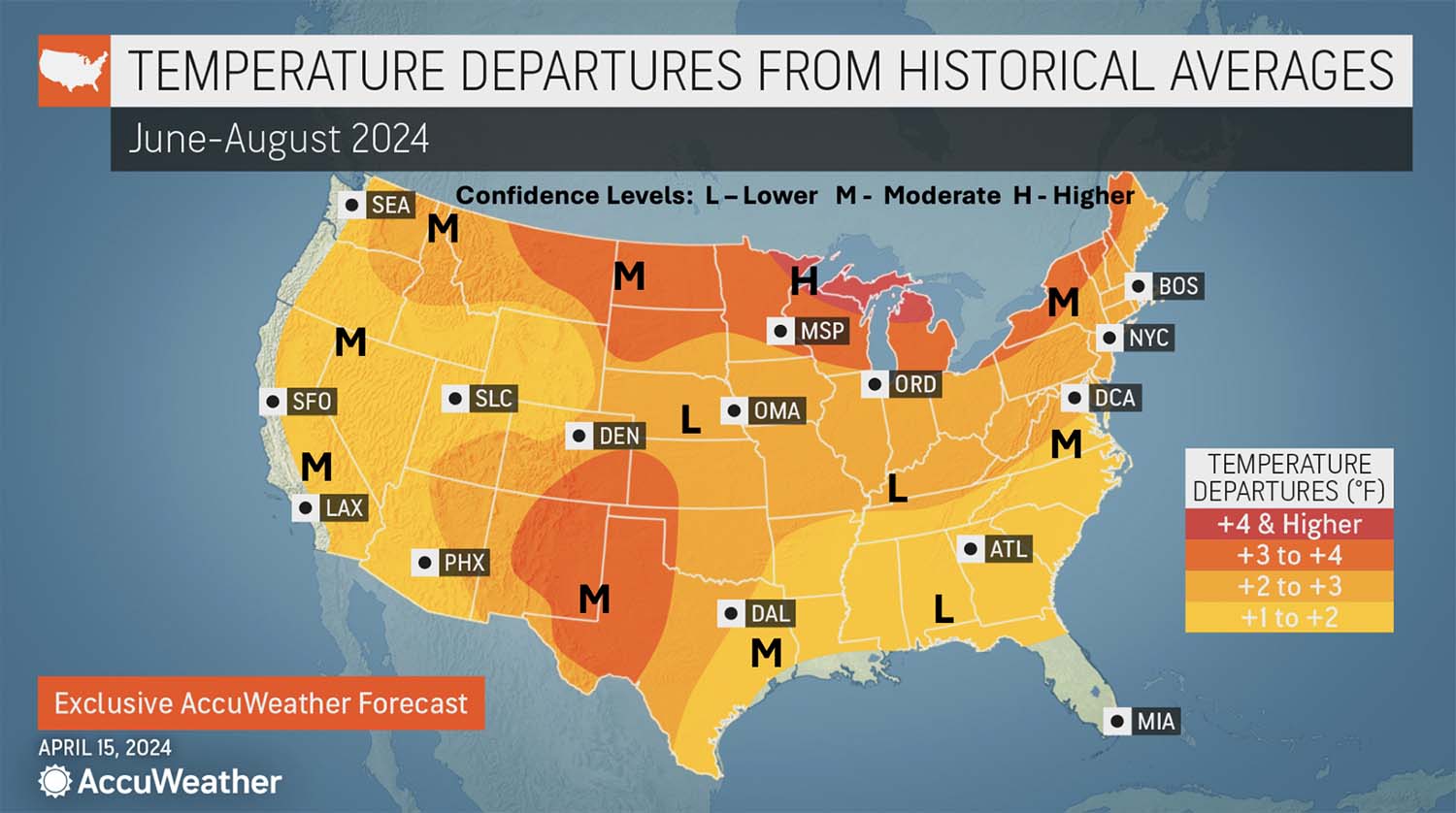
SEEING RED: Above-average temperatures will be mostly inescapable this summer. (Courtesy of AccuWeather)
Ohio Valley and Midwest
Artusa: “During a La Niña summer, the Midwest tends to warm up a bit, compared to normal,” Artusa said.
Connare: Cooler than normal temps with rainfall below average in the east and above average to the west. The hottest periods will be late July and early August. September is also predicted to be wet, with precipitation almost 4 inches above normal.
Pastelok: Could be some rounds of severe weather in June and early July, including some tornadoes and derechos. The amount of rainfall will depend on temps, but still expected above normal.
Deep South
Connare: Hotter and drier than normal, with hot periods in late June, late July, and most of August. Hurricane risk in early July and tropical storms in mid-July. June could have 4 inches less precipitation than normal.
Pastelok: Southeast Texas is a high-probability spot for early tropical development in late May and June, which signals flooding downpours as the gulf opens up.
The wetness will keep temps down compared to averages, but it will result in more humidity, which could make it feel even hotter.
Near typical in Southeast Texas for temps, but farther west will be dry.
“They’re in a drought right now and I don’t think they get out of it,” Pastelok said. “That’s going to have an effect on temperatures — maybe 2-4° above average in the region.”
Upper Midwest
Connare: Warmer than normal, rainfall above normal in the east and below in the west. September forecasted to be much drier than normal.
Pastelok: 3-5° above normal for Northern Minnesota and Northern Wisconsin.
Heartland
Connare: Hotter and drier than normal, with hottest period in early and late July and early and mid-August. Precipitation “way below” normal, nearly 5 inches less, for September.
Pastelok: Typical severe weather, including derechos, usually hit in late May and June before pushing their way into Canada, but that may not be the case this year as there is a blocking high in Canada. This could keep severe weather around into July.
“This could be a zone that is pretty active as far as severe weather goes, and that could cause power outages, which is a big concern,” Pastelok said.
Des Moines, St. Louis, and these areas likely to see 1-3° above normal.
Chances of some heatwaves, but not too extreme due to spring rainfall holding temps back.
Texas-Oklahoma-Kansas, and Nebraska
Connare: Cooler than normal in the north and hotter further south, toward the coast. Looking at hottest periods in late June, late July, and mid-August. Rainfall above normal and tropical storms possible mid-July and late August.
High Plains
Artusa: In the northcentral states (the Dakotas, adjacent states), he said they are defaulting to “equal chances” because this period is categorized as transitional with the El Niño weakening and nearly disappearing. By June, July, and August, La Niña conditions should arrive, and with it, a slow warm-up starting from the south, transitioning the region to above normal temps later in the summer.
Connare: Hot, with hottest periods in late June, mid-July, and late August. Rainfall below normal in the north and above normal in the south.
Pastelok: In Dakotas and Northeast Montana, that area will run drier and drought could be tough at times, likely resulting in higher temps.
Farther south in the foothills (New Mexico, Southeast Colorado), it will be hot, building over the summer. With the monsoon coming later, will stay hot June into July, before backing off around August.
Intermountain
Artusa: In the four-corner states down into the southern great plains, long-term trends are supporting above normal temps. Typically, dryness in this region precedes the June/July monsoon season, which usually lasts until the end of September.
For Colorado, New Mexico, and West Texas, Artusa predicts monsoon season will be delayed and be considered an “underperformer” this year.
Artusa also noted there is a pretty pronounced correlation between what happens in this region and the snowpack in the central Rockies, which was above normal this year.
“Normally, if there’s a lot more snow in say, Colorado, Utah, there’s a tilt in the odds toward a weakened monsoon during that summer,” Artusa said.
In the Southwest, mostly in the vicinity of the southern Rockies/four corners region/West Texas, he also expects to see below-normal precipitation, which again he said is common before the monsoon.
“It looks like the summer monsoon will be off to a delayed start and probably won’t be that impressive,” Artusa said.
Connare: Hotter than normal, with hottest periods mid-to-late July and late August. Rainfall above normal in the north and below in the south. September could be 6° over normal for temperature.
Pastelok: Near to slightly above for temps, hottest and driest weather in August. Will see showers from time to time in June and July, which will hold back temps a bit.
Desert Southwest
Connare: Hot with rainfall below normal in the east and above in the west. Hottest periods are early and mid-June and early and early-and-late July.
Pastelok: Fairly hot and dry, but not too unusual. In Eastern Arizona and New Mexico where it's drier right now, there are going to be big strings of 100°-plus days, maybe getting to that 115, 120 arena in late June and July.
“There’s going to be some extra demand there, some very uncomfortable weather until the monsoon rain starts to kick in, which they probably come in late,” Pastelok said.
This monsoon will be a little wetter than the last two years, but coming in, allowing that heat to expand mid-summer. Should back off in later summer.
“Fire is also a problem early on in the interior Southwest,” Pastelok added.
Pacific Northwest and Northern Rockies
Artusa: A lessened or diminished signal for above-normal due to El Niño losing its influence.
“Once the ocean begins to cool off a bit, it takes the atmosphere a while to catch up,” Artusa said. He’s predicting below-normal precipitation favored for the Northwest, including Washington, Northeast Oregon, Northern Idaho, and Western Montana.
“That, too, is kind of a holdover from the El Niño this past winter,” he said.
But once La Niña gets established later in the summer and fall, then he expects wetter than normal conditions to move into the Northwest.
Connare: Temperatures below normal in the north and above normal in the south, with hottest periods in early-to-mid July. Precipitation slightly above normal with what is called a “summer hangover,” or temps above normal, into September and October.
Pastelok: With La Niña coming on late in the summer, combined with the situation with the water temps in the Northeast Pacific, will result in a higher frequency of cool fronts coming through in June and August.
Some short stints of heat, but otherwise near to slightly above for temps.
Pacific Southwest
Artusa: Expecting it to be above normal, but there’s a wildcard in southern California, especially near the coast, where he sees to be “near normal.”
This area could also see an extended period, or some increased frequency, of marine layer intrusions, which is locally sometimes referred to as “June gloom.” During the “gloom,” the cool, damp ocean air moves inland.
Connare: Temps above normal with slightly above normal rainfall. Hottest periods in early June and early and late July.
Pastelok: Near to slightly above, with no major extremes from the norm. Precipitation should be near to below average and doesn’t see a replay of Hillary from August of last year disrupting the dry season.
Fire at a normal pace, maybe late summer into early fall, which is again typical.
Alaska
Artusa: the central and eastern portions are expected to be above normal, with the western third seeing “equal chances,” especially given how long-lasting the sea ice is expected to be.
“Right now, there’s still just a lot of uncertainty in that area,” Artusa said.
The western half of Alaska is expected to see above-normal precipitation, especially in the northwest, which again is related to the ice cover.
Connare: Warmer than normal with precipitation above normal in the north and below normal in the south. Hottest periods early and mid-August.
Pastelok: Above average precipitation, especially in the south, with temps near to above average. Cooler farther west and northwest.
Hawaii
Artusa: For the big island in the southeast, he’s seeing equal chances for temperatures breaking the norm, and the same for Kapalua, which is on Maui, and the same for Honolulu on Oahu. Once at the northwest corner of the island chain, it tilts toward slightly above normal.
Hawaii is expecting to see a predominately dry summer.
Connare: Cooler and drier than normal, with hottest periods in mid-July and late August.
Pastelok: Below average perceptional going into La Niña with near to above average temperatures. Heightened fire situation on the leeward side of the mountain.


