While this winter is largely forecasted to be slightly warmer with less precipitation, cooler-than-average sea surface temperatures in the Pacific could cause some significant temperature swings, which makes long-term forecasting difficult — both for weather experts tracking snowfall and HVAC contractors tracking heating demand in the cold winter months.
Jon Gottschalck, Chief, Operational Prediction Branch, Climate Prediction Center, NOAA/NWS/National Centers for Environmental Prediction, said one of the things that really stood out from this year’s forecast is just how different it is expected to be when compared to last year.
At this point in time last year, there was a “historically strong” El Niño in place, which is not the case this year.
Gottschalck said 2023/2024’s authoritative El Niño translated to warmer temps across the country, especially in the northern tier, which also coincided with a snow drought from New England to the Great Plains to the Northern Plains and even into parts of the Rockies.
But this year, Gottschalck said, there will be La Niña (albeit a weak one), which will create a lot of variabilities, as there isn’t as much of a strong, seasonal climate driver in place.
“There will be a lot more changes from cold to warm, warm to cold, and so on, as opposed to some of the things we saw last year where we had just persistent, consistent, warmer temperatures — more rain than snow in most places,” Gottschalck said.

Click graphic to enlarge
DROUGHT OUTLOOK: Much of the country won’t get a reprieve from drought, and it’s likely more will form in the south. (Courtesy of NOAA)
That also translates to this year’s weather being hard to predict with a high degree of confidence, especially taking into account climate patterns like the Artic Oscillation or Madden-Julian oscillation.
“Other weather patterns that happen on a shorter time scale will play a very large role in everything,” Gottschalck said, adding that makes things harder to nail down this year. “The uncertainty is much higher.”
Paul Pastelok, senior meteorologist and long-range expert at AccuWeather, is also predicting a weak La Niña, which does make predictions a bit more difficult.
“Whenever you have a weak signal, either La Niña or El Niño, a lot of times, things don’t always work out as they should,” Pastelok said, noting both are big drivers for long-range forecasting. With that in mind, he said his team will likely be updating their forecast more frequently because of this variability.

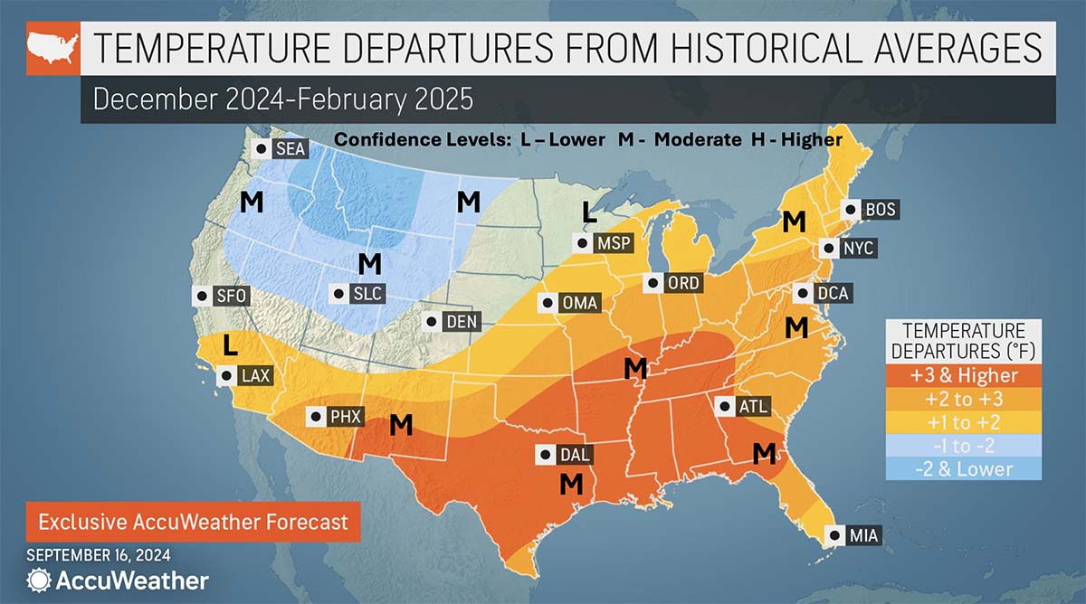
Click graphic to enlarge
LOWER DEMAND: With above-average temperatures predicted, AccuWeather is calling for below-normal heating demand for most of the country. (Courtesy of AccuWeather)
Last year, Pastelok said it was a record-warm winter, but that shouldn’t be the case this year.
“And, this year again, there are going to periods where it’s very mild across the country and there’s not a lot of snow falling,” Pastelok said, “and that could be in the heart of the season in January, where things might quiet down after front-end start and maybe a back-end surge.”
Pastelok noted there was something strange on one of their newer models, which showed not a lot of precipitation on the west coast; rather, it was all concentrated in the country’s interior.
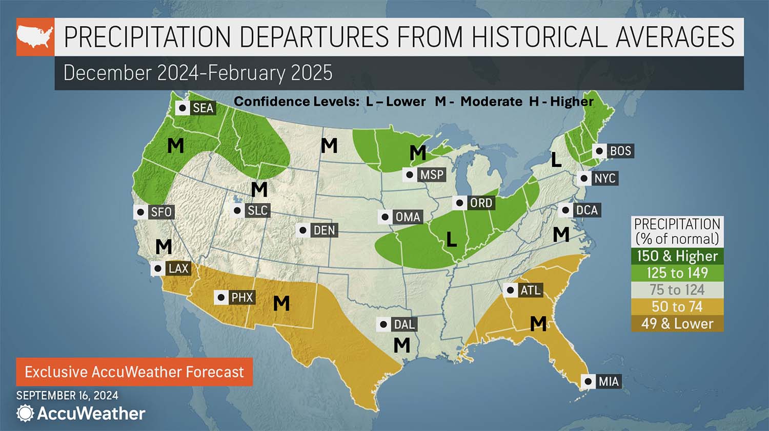
Click graphic to enlarge
MIXED BAG: The predicted precipitation amounts vary, especially between the north and south. (Courtesy of AccuWeather)
“Based on water temperatures in the Pacific, I think that the Northwest will be hit hard at the back-end of fall and into December, and then it may shift down into California for a while in January,” Pastelok said. “They’ve had two good wet seasons in California — this one may not be as wet as the previous two, but it still could have some rain and snow that can have an impact on lower temperatures.”
“I do think that heating demand in the Northern Rockies and Great Basin and parts of the west Interior will be higher than average,” Pastelok said, adding that was one of his more confident predictions for this winter.
Over at The Old Farmer’s Almanac, Carol Connare, editor, is also seeing the same thing — namely, a fairly mild winter for most of the country.

Click graphic to enlarge
MILD AND DRY: With the exception of parts of the southwest and southern East Coast, it’s looking like a mild, dry winter. (Courtesy of The Old Farmer’s Almanac)
“The majority of the country is going to see a winter with above-normal temperatures and below-normal snowfall,” Connare said.
But, Connare added, there will still be plenty of sweater weather and snow for skiing, “just not as severe as winters of the past.”
As always, there are going to be a few expectations, Connare noted — Florida, the Deep South, and Southern California are forecasted to be wetter than normal, and “significant” snow is expected to fall in Central and Southern Appalachia, the Western Ohio Valley, and the Rockies.
As for other areas that typically experience snow, Connare also has some good news.
“It looks like a lot of areas can expect a white Christmas, even though we’re forecasting below-average precipitation,” Connare said.
Connare also sees Western Washington as a stand-out and “highly unusual,” as it’s predicted to have below-normal temperatures and frequent snowstorms beginning in the new year.
Connare also added an important note related to the Farmer’s Almanac’s maps — when looking at areas of the country that are labeled “mild,” that shouldn’t be interpreted as warm.

Click graphic to enlarge
PRECIPITATION PROBABILITY: The outlook is looking much wetter for the north when compared to the south. (Courtesy of NOAA)
“’Mild’ means temperatures will be above normal,” she said.
All three organizations provided region-by-region forecast breakdowns, which can be viewed below.
Northeast
NOAA: Warmer-than-normal temperatures with a slight tilt toward enhanced precipitation near the Great Lakes.
AccuWeather: More of a back-and-forth cold season. October can start mild, then some chilly air masses are possible later in the month. November can be mild for November standards. But it can turn colder toward the end of the month with a couple of cold shots in December. Though we have December near to slightly above, a couple of cold air masses can offset the mild days. January at this point does not look too cold, with above-average temperatures. February can be similar on temperatures, but there is a risk to the forecast. There is a chance that the pattern could change by the end of winter and early spring, associated with the polar vortex. Perhaps a late surge of cold and snow is possible, but confidence is low. This goes for early March as well.
Click graphic to enlarge
HEAT WAVE: Much of the country is looking at warmer-than-average temperatures. (Courtesy of AccuWeather)
Farmer’s Almanac: Winter temperatures will be above average overall. January is expected to be 4°F above average in the far north of this region. The coldest periods will be mid-December and late February. Yes, there will be plenty of snow — however, precipitation and snowfall will be slightly below normal (1 to 1.5% below average). The snowiest periods will be in early December, mid-February, and early March.
Atlantic Corridor
NOAA: Warmer-than-normal temperatures and drier-than-normal conditions for the southern half of the Atlantic coast.
Farmer’s Almanac: Temperatures will be average to slightly above average during winter (though 2% colder than average during February). The region will also experience shots of cold in mid-December, early and late January, and late February. Precipitation will be slightly below normal this winter. In this region, snowfall will be below normal in the north and above normal in the south. The most snow is expected to arrive in late December and late February.
Appalachians
NOAA: Warmer-than-normal temperatures with a slight tilt toward enhanced dryness for extreme southern sections
Farmer’s Almanac: Winter temperatures will be slightly warmer than normal, and below-normal precipitation is expected. The coldest periods will occur from mid-January into early February and in late February. Precipitation will be below normal across the region. However, we expect average snowfall in the north and above-normal snowfall in the southern Appalachians. The snowiest periods will occur in late December, late February, and early March.
Southeast
NOAA: Warmer and drier than normal

Click graphic to enlarge
SOUTHERN SWEEP: Above-average temperatures are predicted for most of the lower portions of the continental United States. (Courtesy of NOAA)
AccuWeather: It looks like a mild and drier winter season once we get by the tropical influence in November. There is still some potential for tropical development in October and even November. In late fall and early winter, the tropics can bring down a cool air mass once or twice. But the majority of the season is mild with dry weather through January at least. Again, we will have to watch February, as discussed in the prior paragraph.
Farmer’s Almanac: Winter will be cooler than normal in the east and warmer than normal in the west. The coldest periods are expected in late November, late January, and late February. Precipitation and snowfall will be above normal. The best chance for snow is in late January and early and late February. Superbowl 2025 is set in New Orleans in early February; this may affect travel, though the Superdome is completely covered.
Florida
NOAA: Warmer and drier than normal
Farmer’s Almanac: Winter will be cooler than usual for the most part: February is expected to be 3°F above average, with near-average temperatures for the rest of the season. The coldest periods are expected in the later parts of November, December, January, and February. Snowfall is not expected; however, rainfall will be slightly above normal across the state of Florida this winter.
Lower Lakes
NOAA: Wetter and wetter-than-normal conditions favored.
Farmer’s Almanac: Winter will be warmer than normal in the east and colder than normal in the west. The coldest periods are expected in early and late November, in early December, and from late January into early February. Precipitation will be below normal in the Lower Lakes region this winter. Snowfall will also be below average, with the most snow in late December, from late January into early February, and from late February into early March.
Ohio Valley and Midwest
NOAA: Warmer-than-normal conditions favored, with enhanced wetness for the northern half of the Valley. Midwest has wetter-than-average conditions favored.
Farmer’s Almanac: Winter will be colder than normal, especially in the month of February (4°F below average). The coldest blasts of winter will come in late January through early February and in late February. The Ohio Valley will experience above-normal snowfall, except for the furthest eastern areas, which will see below-normal amounts. The snowiest periods will be in late December, from late January into early February, in late February, and mid-March.
Deep South
NOAA: Warmer and drier than normal
AccuWeather: The frequency of cold shots, snow, and ice events is down compared to the average. We do not see a deep freeze, but January’s active storm path will have to be watched. Despite forecast well above average temperatures for the second half of fall — and above-normal temperatures, meaning lower demand for heating, for the winter season — we still have to watch for a couple of cold air masses that can move out of the Rockies into the Plains mid-winter, especially if the storm track dips farther south down the West Coast in January and brings the colder farther south in the Plains.
Farmer’s Almanac: Winter temperatures will be consistently warmer than average (about 2°F monthly). The coldest periods will occur in early and late November, from late January into early February, and in late February.
Upper Midwest
NOAA: Primarily wetter-than-average conditions favored, with cooler than normal temperatures for northwestern areas.
Farmer’s Almanac: It’s cold in the Upper Midwest, but winter 2024-2025 will not be as cold as usual. The coldest shots will occur in early November, early and late January, late February, and early March. Precipitation and snowfall will be below average for the Upper Midwest, with the snowiest periods in late November, late December, mid- and late January, early February, and mid-March.
Heartland
NOAA: Cooler and wetter for northern areas and warmer and drier for southern areas.
AccuWeather: (Midwest/Northern Plains Upper) Cool fronts will be brief on the cool-downs following through October. The warm-ups can lead to departures from the month above. In November, the cold pushes can be more frequent and stronger, but still nothing too far from the norm. We are in a La Nina with fast-moving systems. The lengthening of chilly air in the region can be short-lived. December looks colder, by a couple of degrees below average, especially the Dakotas. January, compared to January standards, does not look very cold. The Arctic may be cut off for good periods with less demand for fuel. But snow and ice can still be a concern for workers in the field. The threat of snow and ice is still a concern in February and March, which is why we have above-average snowfall for the upper Midwest and part of the northern Plains.

Click graphic to enlarge
SORRY, KIDS: Most of the country is looking at fewer snow days, except for the Pacific Northwest. (Courtesy of AccuWeather)
Farmer’s Almanac: Winter will be warmer than normal throughout this agricultural area. The coldest periods in the heartland will occur in late January and early and late February. Precipitation and snowfall will be below normal as well. The most snow will fall when temperatures are coldest in late January as well as early and late February.
Texas-Oklahoma-Kansas, and Nebraska
NOAA: Warmer and drier conditions for the southern parts of this area.
AccuWeather: (Midwest Lower and Central Plains) October can be quite mild, especially in the first half, with low demand for heating. Weather conditions can be good, mainly dry. November can be a little more active, with stronger cold fronts, and some colder air following, but nothing too serious. Snow can average below. December is similar to November, but the cool fronts can be quick and some snow can fall in the region at times (generally average snowfall). January looks mild compared to the average, with lower demand on heating. Precipitation can average above, which means there can be rain, snow, or ice concerns quite often throughout the month. There can be some travel concerns. February’s pattern is a little colder but similar as far as storms. The heaviest precipitation may be just east of this area.
Farmer’s Almanac: In terms of temperature, winter will be warmer than average, with the coldest periods in late January and early and late February. We all remember the extreme ice storms and power outages that afflicted this region two years ago; thankfully, the weather this winter doesn’t look as extreme. Precipitation will be below normal, so expect it to be drier than average this winter in Texas and Oklahoma. The best chances for snow are expected in early and late February.
High Plains
NOAA: Cooler than normal for northern areas and warmer and drier for southern areas.
Farmer’s Almanac: Winter temperatures will be warmer than normal in the northern parts of this region — and colder than normal in the southern areas. Expect the coldest periods in early and mid-January and early to late February. Precipitation will be near normal, so don’t expect extremes. Snowfall will be near to above normal, with the snowiest periods in mid-November, mid- and late January, and late February.
Intermountain
NOAA: Cooler and wetter for northern areas and warmer and drier for southern areas.
Farmer’s Almanac: Winter won’t be especially frigid, with temperatures above normal. The coldest periods are in late November and late January. Precipitation and snowfall will be average or above average throughout the Intermountain Region. The snowiest periods will fall in mid-November, early and late January, and mid-March.
Desert Southwest
NOAA: Warmer and drier conditions favored.
AccuWeather: The Southwest should remain warm in October, dry for the most part with drought and some fires a concern. November will also be warm much of the time. There can be a storm that dives south into the central Rockies on occasion, producing some rain and mountain snow, as well as brief cool downs. December is quite mild with very little precipitation throughout the month. The storm track on the West Coast may shift southward mid-winter, and that could bring some rain and mountain snow, especially in January. Also, temperatures can be chillier, but still may average above in eastern areas. February can be mainly dry in the deserts and a little more rain and snow north. Temperatures still near to above average.
Farmer’s Almanac: Temperatures will be colder than normal throughout the winter, with a few monthly variations. January is 3°F above average and March is 3°F below average. The coldest periods will be in mid-November, mid-to-late December, and early February. Expect above-average rainfall. Snowfall will be above normal in areas that normally receive snow, with the snowiest periods in mid-December and early February.
Pacific Northwest and Northern Rockies
NOAA: Cooler and wetter conditions favored.
AccuWeather: This could be a rough winter for the Pacific Northwest. The fall can see a pickup in rain, snow, wind, and some chilly air masses in October and November. October can turn stormy and cooler with an ease-up possible in November. Then it picks up again for December with possibly some heavy rain and snow events, coldest air interior sections. January can be active, but at times the storm track could shift south toward southern Oregon, California, and Nevada. But the storm track could return north again in February and March. Above average snowfall Cascades on East. Coldest air compared to average is interior Northwest and northern Rockies by 2-4° below average for the season.
Farmer’s Almanac: Winter temperatures will be colder than normal in the north and warmer in the south. The coldest periods will fall in early and late January and early March. Precipitation and snowfall will be above average in the north and below average in the south. The snowiest periods will be late December, early January, and early February.
Pacific Southwest
NOAA: Warmer and drier conditions favored.
AccuWeather: (California, Nevada) La Nina is expected late fall and winter, but a few differences can occur. Normal transition from fall to winter can occur in northern California and northern Nevada with temperatures gradually cooling, rain, and snow at times, but near to below average for the fall and December. The storm track could shift south mid-winter and increase rain and snow in the mountains; a few atmospheric rivers can occur. Temperatures will be cooler. Even southern California and southern Nevada can get some rain and a knockdown in temperatures during January. February, the storm track retreats, and northern areas of this region can still be impacted while southern areas dry out again.
Farmer’s Almanac: Winter will be warmer than normal throughout the region. The coldest temperatures will occur in mid-December and mid-to-late January. Expect lots of moisture with a wetter-than-normal winter throughout the entire state of California, with above-normal mountain snowfall. The stormiest periods will be in mid-December, early January, and mid- and late February.
Alaska
NOAA: Warmer and wetter across the northern portions of the state and cooler and drier for areas in the south.
Farmer’s Almanac: Winter will not be as cold as usual — and coldest in December and early January. Precipitation will be below normal. The south and west of this region will see more snow than usual; expect less snow in the north and east. It will be snowiest in late November, December, and early and late January.
Hawaii
NOAA: Warmer and wetter conditions are favored.
Farmer’s Almanac: Winter will be slightly warmer than usual (1% above average) in pleasant Hawaii. The coolest periods will be early and late November, mid-January, and mid-February. The skies will be drier than usual in the east and wetter in central and western areas. It will be stormiest in early November, early January, and early to mid-March.